Office Hours

You are welcome to book your time. We have 6 available 15-minute time slots for for Goose Creek and Twomile Canyon Creek Office Hours. Please feel free to join us in-person at the Main Library or you can attend your appointment virtually online.

Project Overview

The goal of this project is to protect public and private properties, reduce potential damages due to flooding and improve the condition of the creeks. The project aims to maximize natural features in the landscape and ecosystems, protect sections of the existing stream, and improve storm sewer systems to better withstand impacts from climate change.

The community and the city will be working together to rehabilitate the watershed through natural channel restoration, preservation, conservation and restoration of our waterways.

Timeline

  • 2013 Flood
  • 2015- 2016 mapping starts
  • May 2023 UGT Approved by City Council
  • Current Stage - Goose Creek, Reach 6 Community Collaboration (1-3 years Design Process, 8-16 Months Construction)
  • Future mitigation phases

Goals

  • Protect life and property
  • Reduce high hazard zones and floodplains
  • Preserve the watershed and stabilize the streams
  • Accommodate precipitation from minor and major storms
  • Create resilience for the future

Methods

  • Mimic natural stream channels with engineering
  • Create slope and depth variability in the stream bed
  • Repair stream banks
  • Reduce bank sediment by implementing stabilization and natural channel design

Project Outcomes

Incorporating natural channel restoration into flood mitigation projects can lead to a more vibrant, sustainable and resilient community and environment.

  • Flood Mitigation: Restored natural channels can absorb excess water during heavy rainfall, reducing the risk of flooding in neighborhoods.
  • Property Protection: Stabilized stream banks help prevent erosion, and protect homes and infrastructures located near streams.
  • Improved Water Quality: Natural channel restoration filters out pollutants and sediments, leading to cleaner water.
  • Educational Programs: These projects can serve as educational tools, promoting awareness about watershed health.
  • Community Engagement: Natural channel restoration projects offer opportunities for community members to get involved through volunteer efforts, workshops, and collaborative planning.
  • Climate Resilience: Restored natural channels are better equipped to handle impacts from climate change, providing a more resilient buffer against extreme weather events.
  • Wildlife Habitat: Restoring natural habitats can create homes for diverse wildlife species, enriching the local ecosystem and offering opportunities for wildlife observation.

Flood Mitigation Plan

Twomile Canyon Creek begins in the foothills west of the city, following Linden Avenue, until meeting the western city boundary where it exhibits more unconfined, alluvial fan type flow patterns. Runoff continues through residential and commercial areas, fanning out into several pathways over streets and through private property. 

Image
Goose Creek and Twomile Canyon Creek Flood Mitigation Concept Design - full description follows the image.

Click the image above to expand the Goose Creek and Twomile Canyon Creek Flood Mitigation Concept Design. 

Mitigation for 4 reaches can be described as follows:

Twomile Reach 1 Spring Valley Dr. and Linden Ave. Culverts with optional sediment basins

Twomile Reach 2 Less than 100-yr channel improvements with culvert crossings at Kalmia Ave. and Juniper Ave

Twomile Reach 3 100-yr capacity box culvert Broadway to 19th St. with possibility of partial open channel conveyance along Iris Ave. and back to Hawthorne Ave

Twomile Reach 4 100-yr capacity box culvert in 19th St. with possibility of partial culvert conveyance along Floral Ave

The Upper Goose Creek watershed runoff begins in the western foothills, collecting in North Boulder Park, and continuing easterly through the urban portions of the city.  Mitigation for 6 reaches can be described as follows:

Goose Reaches 1 & 2 100-yr culvert & open channel – North Boulder Park to Broadway

Goose Reach 3 100-yr capacity box culvert Broadway to 13th St.

Goose Reach 4 100-yr open channel from 13TH to 17TH Between Alpine and North Streets

Goose Reach 5 100-yr Box culvert across Alpine Condominiums

Goose Reach 6 100-yr open channel 19TH St to 24TH St

Nature-Based Design

The city strives to help protect people, places, property, and ecosystems in a way that builds resilience and is consistent with community values.

Community Engagement

Q4 2023 - Community Meeting - Upper Goose Creek and Twomile Creek Community Meeting. 6 to 7 p.m. on Nov. 15, 2023 at Foothill Elementary School.

The purpose of the meeting was to provide updates on the Upper Goose and Twomile Canyon Creek (UGT) Flood Mitigation Plan and timeline for next steps.

May 18, 2023 - City Council, Public Hearing - Staff presented the plan to City Council for approval.

March 20, 2023 - WRAB Meeting
The Water Resources Advisory Board made their recommendation to send the plan to City Council. Pending City Council approval, concept and preliminary design will move forward.

Dec. 7, 2022 - Information Session
On Dec. 7, 2022 we held an information session to meet the new project manager for the Upper Goose & Twomile Canyon Creek flood mitigation project, learn where we are in the project process and ask questions.

Frequently Asked Questions

At what point during the design phase will the plan/design be submitted to the US Corp of Engineers for permit approval? What is required from COB to submit to US Corp of Engineers? (i.e. environmental impact report?) Upon initial contact with the Army Corps of Engineers (ACOE), the city will request a determination of ACOE requirements, which may include an environmental impact report. Before submitting the application, city staff will have high-level discussions with permitting agencies to proactively address any anticipated issues.

When do the following items happen: Tree inventory, nest inventory, wetland permitting, detailed cost estimates? Collecting data through a survey of existing conditions, including inventories of trees and other vegetation, wetlands, wildlife, nest inventories, and other existing features, is the first step after consultant selection. This data is then used to inform the design. The city will apply for formal wetland permits and develop detailed cost estimates once a final design is reached.

At what point during the design phase will residents be contacted about easements on private properties? Typically, the easement negotiation process begins in the first or second thirds of the design process. As soon as the project team has enough design details to talk about easement specifics, such as easement width and location, staff will reach out to individual property owners.

What happens if residents reject COB easement proposals? The city’s intent has been and will continue to be to work with property owners to achieve mutually beneficial easement access. The city has been successful with this approach to date and there has not been a need to vary from this approach.

Will City Council be vetting and approving the design of the mitigation plan? Will there be another vote? While there is not a formal city council step, the project team is committed to transparency and any significant update to the design or process will be brought to council over the course of the project.

What did City Council approve? City Council granted approval of the Upper Goose Creek/Twomile Canyon Creek Mitigation Plan PDF, signifying the endorsement to advance into the design process. The approval extends specifically to funding for the design phase and the initial first phase of construction. There has not been an approval for any specific design details at this point.

When will construction begin? Once the design alternatives are selected, detailed construction plans, cost estimates, bids from contractors and construction schedules will be prepared. Construction on some reaches is tentatively set to begin in 2026. Property owners and community members will be fully informed before construction.

Who is responsible for clearing all the fallen and growing trees in Two Mile Creek? If it is homeowners, who is responsible for letting the homeowners know and what if they don’t/won’t do it? When streams are located within a city drainage easement, the city flood maintenance crew and/or the Mile High Flood District will typically clear debris that causes a flow blockage and associated flooding concerns. Access maps of city easements through the Self-Service Map Application Form. When streams are located on private property without a drainage easement, homeowners are responsible for stream stewardship and maintenance as detailed in Boulder Revised Code and are encouraged to follow the below guidelines. Concerns about creek maintenance are most efficiently reported through the city’s Inquire Boulder system under Utilities: Creek and Culvert Debris.

Creek Stewardship and Stormwater Quality Guidelines

  • No Dumping: Avoid dumping yard waste, trash, or any material in the stream channel because it may wash away in a storm causing debris jams and pollution. Remove dead and overgrown vegetation that has evidence of contributing to debris jams or could contribute to a debris jam if it becomes dislodged.
  • Preserve a Riparian Buffer: Promote the growth of dense grasses adjacent to the stream bank. If possible don’t mow within 25 feet of the stream channel.
  • Avoid Fertilizer Use: Avoid using fertilizer adjacent to stream banks unless soil testing shows it is needed.
  • Remove Noxious Weeds: Identify and remove noxious and invasive weeds. Be on the lookout for the most common list A noxious weeds found in Boulder drainages: Purple Loosestrife, Japanese Knotweed, Hairy Willow Herb, Yellow Flag Iris, and Myrtle Spurge. Additional information on noxious weeds.
  • Repair Erosion: Look for eroding stream banks on your property. Preserve existing vegetation to help with stream bank stabilization. When streambank erosion problems are present, use vegetative stabilization approaches instead of adding rock and consult with a professional to determine the best approach. Only plant native species well adapted to Colorado’s Front Range riparian ecosystems.

Image
Bank Erosion

The Keep It Clean Partnership provides additional general information for community members about how to support stream health.

Based on the project plan description (e.g., nature-based solutions, removing non-native plants, reducing erosion, planting native plants), would you describe this as an Upper Goose corridor restoration project? Yes. A major focus of the effort is creek restoration. The focus on nature-based solutions, removal of non-native plants, erosion reduction, and the planting of native plants aligns with the principles of ecological restoration commonly associated with corridor restoration projects. The emphasis on restoring the natural habitat and promoting biodiversity in the Upper Goose corridor suggests a comprehensive restoration initiative aimed at enhancing the ecological health and resilience of the area.

How does the negotiation with homeowners work and has the city considered these costs? The city will be contacting individual homeowners and coordinating their input as soon as we have enough design details to share to inform the conversation. Easement negotiations are a standard part of flood mitigation projects and included in the city budget.

Type of machinery? How will machinery access ditch to widen or dig? Is there a risk of structural damage to a home's foundation when heavy equipment is used in close proximity to the property? The project will involve heavy machinery and will not result in structural damage to homes or foundations. The city takes public safety and property considerations very seriously and is accustomed to managing large construction projects. Access routes will be determined as part of the planning process and prior to any ground disturbance.

How can we ensure that quieter voices are heard in this discussion? Many renters in the Goose Creek floodplain may not know but will be impacted by these choices. To ensure all voices are heard in the discussion, we'll implement inclusive outreach strategies, including building strategic partnerships with property managers, Boulder Housing Partners, and other rental agencies. The city will also post information in public and community-based spaces, such as recreation centers and local shopping areas to reach people where they are. Other forms of communication include community meetings, office hours, one-on-one conversations, flyers, and social media, among others.

Does the city inform people of the flood risk? The tragic loss of life in the Twomile watershed was a significant event and flood mitigation is targeted at improving life safety. Detailed information about flood preparedness and city and individual actions can be found in Chapter 9 of CFS Volume II PDF. Sign up to receive emergency alerts go to BoCo911Alert.com.

What do you mean by “community engagement” in the Design Stage? The design team will actively meet with community members in public meetings, information sessions, remote meetings, and office hours to hear ideas, concerns and gather information. Emails are always a way to connect, and staff are committed to answering questions and sharing feedback on how the public input influences the decisions. Community input can significantly influence project elements, such as whether public access along the creek is allowed or which alternatives are considered. Community ideas are given serious consideration and are implemented within the technical constraints of the project when feasible.

What real decision-making power do we have? How much influence will individual property owners have over the design of the work adjacent to their properties? The community can have significant influence on flood projects, and we will work with you to ensure that your concerns and aspirations are reflected in any alternatives and share feedback on how the public input influenced the project. For example, in response to community feedback, City Council directed staff to advance a piped alternative alignment in Floral Drive to reduce impacts to properties adjacent to a portion of Goose Creek, Reach 6. This example shows how partnering with the community and decision makers like City Council in carefully weighing project tradeoffs is at the heart of the engagement process.

In the case of private properties that involve the need for easements, individual negotiations will occur with each individual property owner and the city will accommodate as many requests as feasible.

At what point do you anticipate the impacted properties to be removed from the 100-year FEMA map and city restrictions? Typically, the FEMA and city requirements are removed a couple of years after project construction is complete. The agreed upon design must be submitted to FEMA, approved, and then put out to bid for construction. Once construction is completed, the as-builts of the project are re-submitted to FEMA, and once accepted, FEMA issues the Letter of Map Revision which effectively removes the floodplain designation from affected properties.

Structures removed? What does this mean? Physical buildings, homes and structures will not be moved or disturbed as part of the project. However, their designation as “in” or “out” of the floodplain may change. The project will direct water away from structures presently in the floodplain. This will effectively remove the designation for these structures as being within the floodplain boundaries and decrease or eliminate the requirements for flood insurance. The overall idea is to enhance drainage and reduce flood risk while preserving residential structures. This approach aims to create a more natural and open channel for water, ensuring the safety and resilience of residential areas during potential flood events.

Will the city condemn houses along Twomile Ditch? There are no plans to condemn any homes.

Project terminology is confusing. Mitigation typically happens after design and planning. Show the actual outreach events instead of just calling it design and construction, i.e., design/outreach/construction. We can appreciate that project terminology can be confusing, and staff are available to help clarify anytime. Before design can happen, the project concept, extents and funding required are outlined in a Mitigation Plan that is then presented in public hearings and approved by City Council. The Upper Goose Creek and Twomile Canyon Creek Mitigation Plan is the document that describes the project in these broad terms. You are correct that actual mitigation, versus the mitigation plan, occurs after project construction.

How can I stay informed on the Goose Creek Reach 6 project? Following City Council approval of the Upper Goose Creek and Twomile Canyon Creek Flood Mitigation Plan on May 18, 2023, the plan has moved into the design and construction phase where more specific details can be developed and discussed with the community. For the most up to date information and opportunities for continued community engagement, please visit the website and sign up for email updates. You can also email specific questions to urregoa@bouldercolorado.gov

Were community preferences and concerns considered, and will there be more opportunities for community engagement as the mitigation plan proceeds? Yes. The city understands the continued concerns of the community and the desire for details. As the project proceeds the city will be informing affected property owners about the configuration of the improvements, acquiring drainage easements along the necessary reaches, and providing private property protection during construction.

What kind of disruption/interruption/commotion should neighbors expect behind his property and for what length of time as mitigation moves forward? The city recognizes this is a huge concern and will be fully transparent and have discussions with owners as the plans and construction schedules are put together. More detail will be provided for each property owner once plans are finalized as we work through the design and continue to receive feedback through engagement in the development of the plans.

What’s the specific plan for the lowest part of Alpine Avenue and 20th/19th? It floods a lot (3 times in 10 years). What exactly are you doing? Physical work – is this in the Design Phase? This is a known area of concern that will receive attention in a future phase of UGT flood mitigation. The downstream channel improvements need to occur first to have the capacity to receive additional storm water from upstream.

Will flood mitigation be included in the design of the Iris transportation plan? With the initiation of the Iris Avenue traffic/bike path project, has Iris been considered for potential underground flood mitigation? (With the hope that this would contribute to a smaller channel required at UGC6). Why not put all the undergrounding under Iris when they tear it up for that project? Design for both the Transportation and flood mitigation projects are a few years out. The two projects are in initial conversations to explore opportunities to maximize and optimize each project and will continue as each proceeds. Only a fraction of the Twomile Canyon Creek runoff gets to Iris Avenue as much of the stormwater follows a different path prior to reaching Iris Avenue.

Can we construct a wetland on a portion of North Boulder Park to help attenuate flood waters in the area? Based on community input during mitigation plan development and also the physical constraints of the site, North Boulder Park detention was eliminated from the mitigation plan in earlier project planning phases. More specifically, groundwater is too high to provide any detention capacity and is infeasible as a storage option.

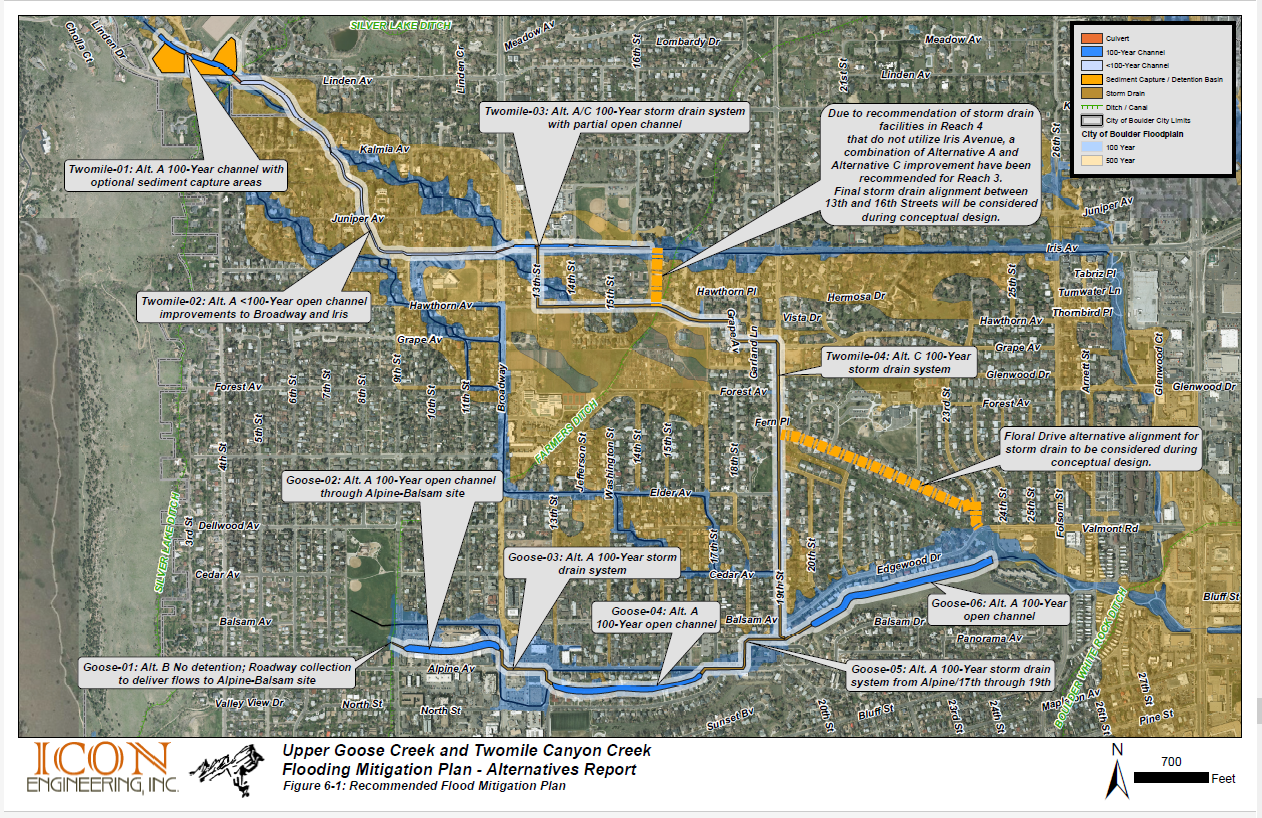
Is there a realistic way (in terms of cost and complexity) to address Goose Creek without widening/clearing the channel? No project alternative eliminates the need for work within Goose Creek Reach 6 because of the area’s geography. Reach 6 is the natural low point of both Upper Goose and Twomile Creeks. The amount of water that would flow to this area in a 100-year event would be approximately four times the amount that flows through Boulder Creek during peak spring runoff. Currently, the channel struggles to pass water in a heavy summer rainstorm. The project team is looking at alternatives that would minimize the amount of water that would flow through this reach in a flood event, however some channel work would still need to occur to improve flow conveyance, stabilize eroding streambanks and to restore the natural stream function.

Construction and development near 4th and Linden over the last 15 years seems to have diverted water from Linden southeast toward Foothills Elementary. Will that be reversed or mitigated? The evidence for this is the revised flood maps after 2013. Any development in city limits is subject to Boulder floodplain and wetland permits and cannot cause any adverse impacts. Nevertheless, flood mitigation is planned for this area, which will be addressed in future projects phases.

Has the cost of undergrounding been compared to channel construction (presumably along Edgewood)? How is the project paid for? The project team is evaluating the estimated cost and feasibility of an underground option under Edgewood and will share the final report when it’s available. Flood projects are paid for by Stormwater and Flood utility fees included in monthly utility bills and in partnership with the Mile High Flood District.

Will Upper Goose Creek be channelized like Goose Creek east of Folsom? If so, why has Boulder abandoned flood zone policy? No. The design for Upper Goose Creek along Reach 6 will have a more natural feel and will not be hardscaped. Channels that mimic natural flood conveyance where possible are preferable because they are typically less costly, more sustainable, more resilient to flooding events and require less maintenance. The 2022 Comprehensive Flood and Stormwater Master Plan and current Mitigation Plans promote this nature-based approach.

What's going to happen with Twomile Canyon at Broadway/Iris before water gets to 19th? This area is currently being evaluated and we’ll share more information when an approach is known. Any mitigation will occur after downstream capacity is established.

Could you please provide more information about the possible alternatives under consideration for the implementation of "UGC Reach 6"? Specifically, I’d like to understand why the city is recommending improved conveyance of Goose Creek instead of piping flood flows under the roadway. The City of Boulder prioritizes a nature-based approach to flood mitigation citywide as it restores natural stream functionality, increases resilience to flooding events, enhances urban ecosystems and supports the city’s climate goals. Such an approach is in alignment with national trends, industry standards, and the 2022 Comprehensive Flood and Stormwater Master Plan (see excerpt below). The current recommendation for Upper Goose Creek Reach 6 proposes improving channel conveyance and restoring the stream channel using this nature-based design approach.

Previous investigation of a piped alternative under Edgewood indicated that such an approach was not viable. However, given community interest, the team will take another look at a more detailed design to see what it would take to route flood flows under the road and share that report with the community when it has become available.

Is there still an alternative to convey Twomile Canyon Creek flow down Floral Drive to reduce flows along Goose Creek? Yes. The Floral Drive alternative has been included in the flood mitigation plan and is currently being evaluated in more detail. City council communicated a preference for the Floral Drive alternative and additional design details will be provided to the community when we have more information available.

Will there be public access along Goose Creek Reach 6 as part of the project? No. Public access is not included in the Goose Creek flood mitigation plan for Reach 6. There is also no reference to future public access in the Transportation Master Plan or Greenways Master Plan, which all generally guide future city projects that have been approved by council.

What are the details in the mitigation plan for the size of the culverts, and the width and configuration of the proposed channels, and what will the channels look like? The design of the details will not occur until after the mitigation plan is approved by City Council, and as that process moves forward, the community will be informed of the design as it is developed. More detail will be provided for each property owner once plans are finalized as we work through the design and continue to receive feedback through engagement in the development of the plans.

Was any consideration given to utilizing additional street conveyance down Iris, Edgewood, and other streets rather than the alternatives shown? The streets collect water in a storm sewer system that is not sized for a major storm event, so streets are currently conveying excess stormwater. Increasing the depth of water even more could result in turning them into high hazard zones, jeopardizing life safety and emergency access.

How were the alternatives scored to make the decisions presented in the mitigation plan? After the results of the community outreach to create alternatives for the various reaches of the UGT creek system, the community was encouraged to vote on preferences. This information was combined with the community values described in the CFS, and the results were tabulated and given scores to determine the priorities and preferences in a general sense for the mitigation plan.

Do the mitigation plans include things like debris and blockages? Debris, damage, blockages and clogging are always considerations for the design of storm sewers, channels, box culverts, and all the elements of flood conveyance. The hydraulic model includes blockages ranging from 10% to 100%, depending on conditions and the storm event.

Will the revised floodplains be constructed with concrete-lined channels? No. There are no plans to construct concrete-lined channels, as this is contrary to the current thinking, guidelines, wetland regulations, water quality considerations and desires of both the city and the community. The intent is to construct sustainable, attractive, re-vegetated stream corridors that encourage natural riparian habitats and wildlife ecosystems.

Why is flow from Twomile Canyon Creek being directed toward Goose Creek along Edgewood, with modifications to Goose Creek on that reach, and won’t that increase the flood risk to those areas, causing those homes to be flooded? Historically, water flows overland from Twomile Canyon Creek toward Goose Creek, and it will continue to do so, regardless of improvements upstream. The city will not revise any floodplain to put any homes at further risk from additional flooding than before, and reconfiguration is intended to lower the water surface elevation in a flood event, removing homes from the floodplain where possible, decreasing the overall risk for homes. Even though this portion of the creek did not flood significantly in 2013, flooding could occur in the future from the more typical flood event.

If Goose Creek is widened between 19th and 24th St. are the engineers considering the difficulties and costs to stabilize the existing steep slope and protect the homes on the south side of the creek? Yes. Portions of the existing slope are already experiencing severe erosion and deteriorating trees that can lose the root structure and put the area at risk of further slope failures. A detailed and thorough geotechnical investigation to design appropriate slope stability is a key element of the improvements to this reach of Goose Creek.

Why are multiple paths shown on the mitigation plan for Twomile Canyon Creek south of Linden Ave.? The multiple paths shown on the mitigation plan represent the problem. The loss over time of the original creek channel has caused the flow to deviate from the main channel of Twomile Canyon Creek into other pathways, meandering through local streets and neighborhoods south of Linden both east and west of Broadway until it re-enters Goose Creek, and is joined by flow from Elmer’s Twomile Creek, just east of Valmont and 28th. This results in substantial flooding of those streets and residential areas.

If there is not enough room for the “100-year” channel, why doesn’t the city use imminent domain law to acquire necessary land for public good between Linden and Broadway instead of designing the channel for less than “100 -year” flood conveyance? Respecting the wishes of the community and the residents of the neighborhood is extremely important. Forcibly taking over property is very rare. The city will negotiate with the private property owners to acquire drainage easements prior to any final plans or construction. In some instances, private property owners are willing to vacate their property and sell it to the city, and when appropriate, the city will consider purchasing the property.

Will Twomile Canyon Creek mitigation east of Broadway handle the “100-year” flood? The proposed mitigation plan will convey the “100-year” flood in this reach to 19th Street, with a combination of an open channel along Iris Avenue and storm sewer improvements along 13th Street, Hawthorn Avenue, 16th Street, and Grape Avenue. The exact alignment and combination will be determined in the next phase of design development.

Is there an opportunity with Alpine Balsam to restore some natural features/wetlands at North Boulder Park and below? Yes! The Alpine Balsam project, which is located in the upper reaches of Goose Creek, will include a large channel with natural features using nature-based design principles. More information about the Alpine Balsam project can be found at Alpine-Balsam-Implementation.

Will you be estimating the carbon footprint of different project construction alternatives, e.g., concrete to pour versus more use of natural features/channels? The 2022 Comprehensive Flood and Stormwater Plan promotes use of nature-based design. Although difficult to measure specifically, the restoration of native vegetation in stream corridors and minimizing the use of concrete is consistent with a lower carbon footprint.

Please clarify boundaries for Goose Creek. What would hold more mosquitoes (before or after?) When there is low water, would it be mud or more like current situation, like grass and trees currently in Parkside Park and further south? (My story: 2013, lost full basement because of backflow of water possible shutdown of wastewater treatment plant? No financial help because it wasn’t considered “flood”.) We know many in the 2013 flood experienced personal losses like you describe. One of the key flood mitigation project aims is to prevent further damage from future flooding. Nature based design will result in stream restoration that mimics a natural stream as closely as possible, and will include native vegetation, riparian habitats, and varied stream bottom treatments as natural streams have. Mosquito counts are not typical in design, but healthy stream habitats, with efficiently moving water typically do not support large mosquito populations. The channel in Parkside Park is an irrigation ditch, not a natural stream channel, and has different goals and characteristics.

Are there traffic impact studies for undergrounding under Edgewood? (during construction). Every construction project within the street right-of-way is required to have a detailed traffic control plan to address traffic impacts.

How will impacts to environmental resources (wildlife, vegetation, wetlands, etc.) in Goose Creek Reach 6 be considered? Any work in streams requires extensive permitting and oversight from Federal, State and local agencies, including the Army Corps of Engineers, US Fish and Wildlife, Colorado Department of Public Health and the City of Boulder. Prior to any construction, permits for impacts and any mitigation will need to be approved by these agencies. Agency findings and mitigation strategies will be shared with the community on the project website.

Is the city considering the value of Upper Goose and Twomile Canyon Creek as a wildlife corridor? Yes, absolutely. The city is committed to environmental stewardship and protection of streams and riparian wildlife areas, which are valuable ecological and community resources. Restoration will include removal of non-native vegetation and re-introduction of native vegetation to support the natural ecological environment, the return of native wildlife, and creation of more sustainable habitat.

Has the City accounted for the past and possible future wildfires in the Twomile Canyon Creek watershed? The city is aware that wildfires increase the chances of flooding from debris and additional runoff. This is even more of a challenge given that finding adequate space is already difficult. The majority of the fire risk area is in the watershed located west of the city limits of Boulder, in Boulder County. Additional information for the County can be found here:
Boulder County Wildfires (arcgis.com)
Creek Recovery & Restoration Program - Boulder County

In the 2013 flood event, some areas of the city experienced extensive flooding and damage, and other areas did not. What was the final declaration for the 2013 flood event related to both Upper Goose Creek and Twomile Canyon Creek? Some reports declared it a “100-year” event, and some did not. In September 2013 Boulder and the uphill watershed received up to 18 inches of rain in a few days. This exceeded the total precipitation normally received in an entire year. Some areas of Boulder received the “100-year” intensity of precipitation, and others did not, resulting in unpredicted and varying flood levels. The flood designations vary depending on the location and duration considered.

Latest News