Thank you to the Boulder community!

Open Space and Mountain Parks staff appreciates our community's assistance in helping us recover from the historic September 2013 floods. Learn how we worked together to repair and rebuild flood-damaged open space areas.

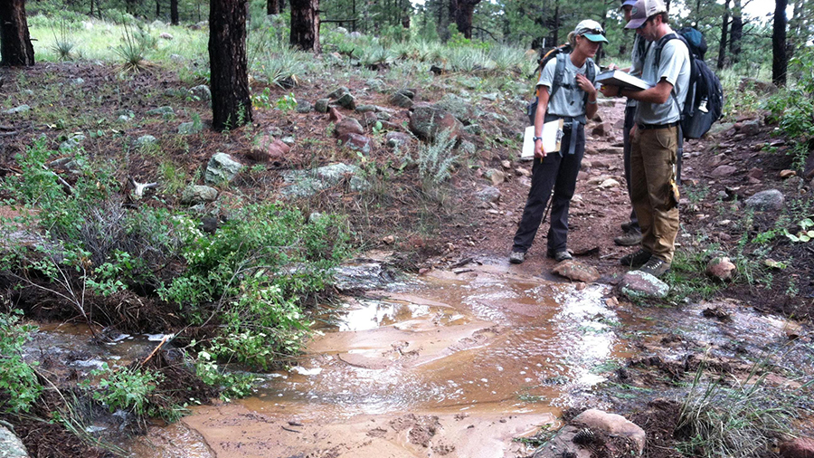
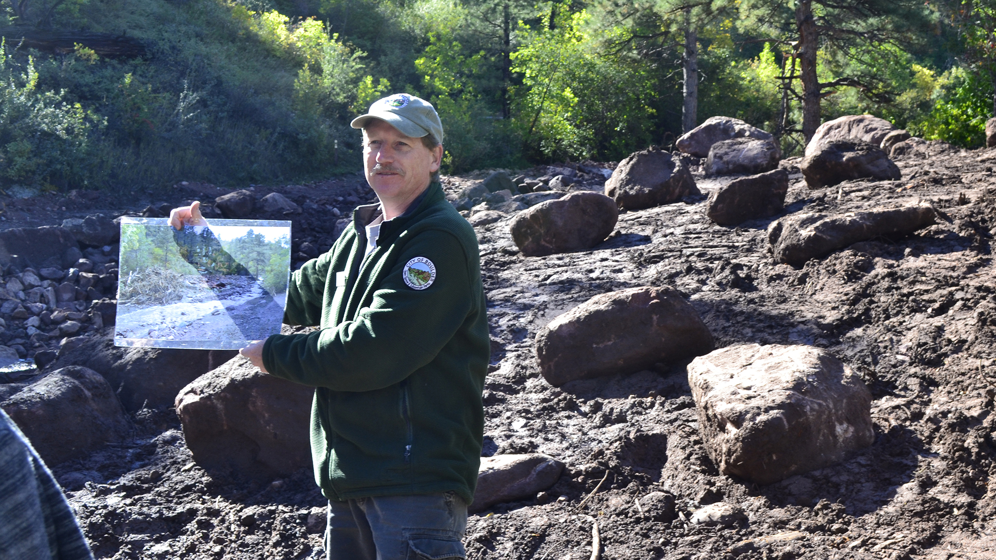
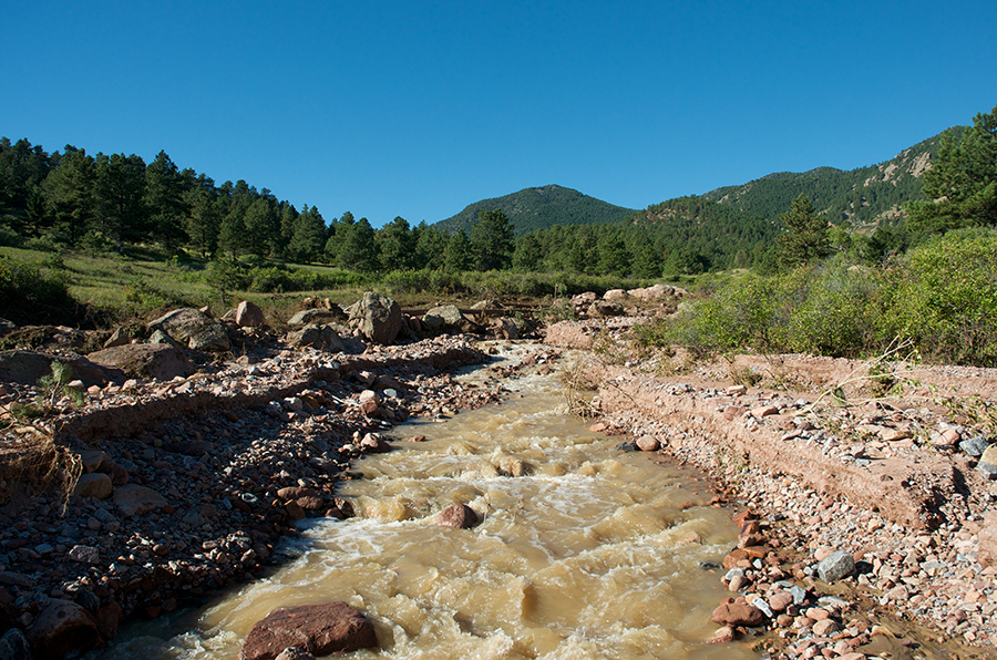
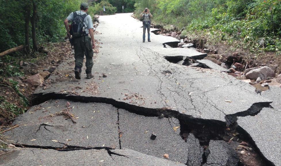
During the historic September 2013 flooding, the exceptional force of water, combined with gravity, moved massive amounts of earth and vegetation.

When the flooding stopped and the clouds finally parted, an initial damage assessment indicated that about 40 miles of the city’s Open Space and Mountain Parks (OSMP) trail system sustained significant or severe damage, while more than 100 miles suffered at least minor damage. The floods also damaged sensitive ecological areas and caused extensive damage to open space agricultural infrastructure.

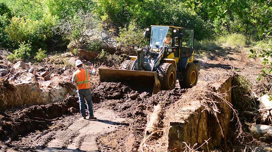
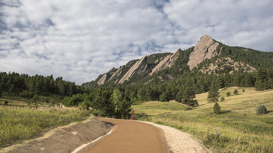
After the assessments were completed, the damage to open space was clear: It would take years for the city’s open space system to recover from the historic flooding. As the 10th anniversary of the September 2013 floods nears, Open Space and Mountain Parks staff wants to extend our deep gratitude to generous community members who helped us rebuild in the wake of the historic flooding.

All told:

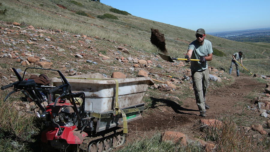
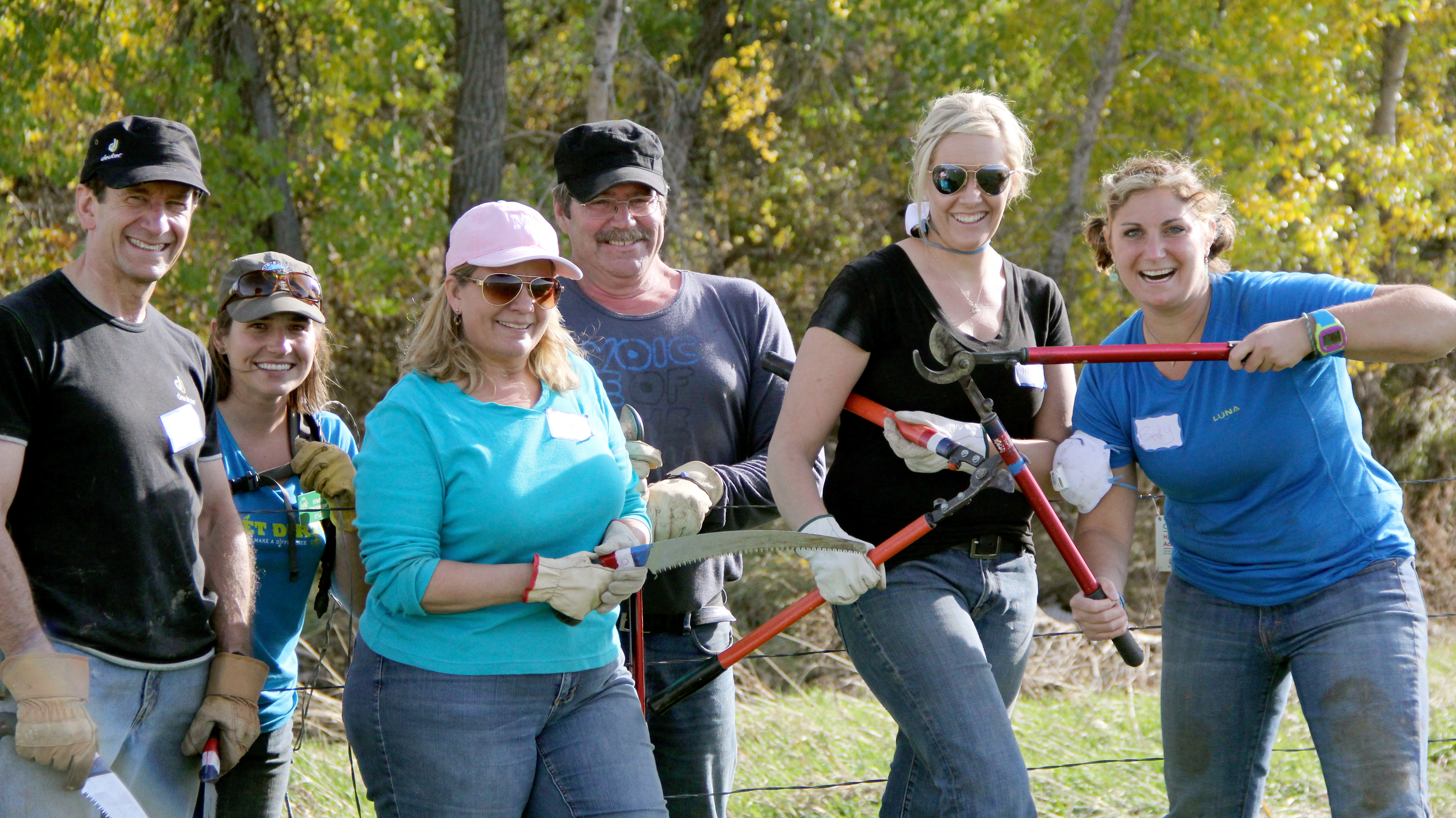
  • More than 1,480 volunteers donated 8,000 hours to help rebuild and restore shared open space.
  • They helped OSMP to complete more than 120 projects to repair trails and restore areas affected by the floods.

Read further below or view an online story map to learn more about our work to recover from the floods. We couldn’t have done any of our flood recovery work without you. We are truly fortunate to work for a community deeply connected to the land, and we’re proud to help our community enjoy and protect shared open space.

Damage Assessment

Evaluating Trails and Trailheads

For four days following Wednesday, Sept. 11, 2013, floodwaters and persistent rainfall prevented Open Space and Mountain Parks (OSMP) staff from cataloging the full extent of the flood's damage. Finally, when the rains began to subside on Monday, Sept. 16, OSMP staff assembled in a small conference room. A map of the entire trail system, separated into dozens of zones, lay on a table in front of them.

Teams of two to three staff members were tasked with hiking all trails in their zone to catalog the damage, identify the likelihood of whether major or minor repairs were needed, and determine whether trails were safe and passable for the average visitor. When the assessment teams returned, the damage to open space and its effect on the community and OSMP became clear: It would take years for the city’s open space system to rebuild from the historic flooding.

Image
OSMP employees evaluate flood damage in 2013

OSMP trail crew members assess trail damage from the September 2013 floods.

The Floods' Toll

Damage Across Open Space

City of Boulder Open Space and Mountain Park (OSMP) trails, trailheads and bridges that sustained significant damage during the 2013 floods included:

  • Chautauqua Trail
  • Royal Arch Trail
  • Boulder Falls
  • Gregory Canyon Trailhead and access road
  • Sanitas Valley Trail
  • Chapman Drive
  • NCAR-Bear Canyon and Mesa trails
  • Shadow Canyon South and Mesa Trail
  • Foothills South Trail
  • Shanahan Ridge trail system
  • South Mesa Trailhead
  • Doudy Draw, Skunk Canyon, South Boulder Creek bridges

There also was extensive damage to the city’s water and agricultural infrastructure. Several irrigation ditches that supply water to agricultural operations, such as the Green Ditch and the Eggleston #2 ditch, needed repairs. At the same time, about 45,000 feet of agricultural fencing was destroyed, and an additional 33,000 feet sustained damage. While floodwaters can be beneficial in many cases, the 2013 floods also disrupted important stream corridors and would require substantial ecological restoration.

Reconnecting Visitors to Open Space

Steps to Reopen Trails

Recognizing that community members needed a space to heal from the floods, OSMP prioritized trail repair work that would reopen popular trails to help as many people reconnect with the land – as fast as possible.

By September 30, 2013, the department began reopening significant sections of several major trails. Then, week after week, the department opened more and more trails. By November 1, 2013, the department had reopened 108 miles of trails – or about 75 percent of its 145-mile trail system.

Throughout the fall of 2013, OSMP staff trail crews – and teams of generous volunteers – conducted significant repairs on important open space trails, including the Bear Canyon, Skunk and Bobolink trails. Smaller repair projects on the Goat and Fern Canyon trails and several others helped visitors reconnect with OSMP’s dramatically changed open space system. By the end of 2013, the department was able to reopen 95 percent of its 145-mile trail system. However, significant flood repairs still loomed.

Image
An OSMP staff member works to complete temporary trail repairs along a flood damaged trail.

An OSMP staff member works to complete temporary trail repairs along a flood damaged trail.

Community Resiliency

Volunteers Helped Rebuild and Restore Open Space

Before the floods even subsided, Open Space and Mountain Parks began receiving calls from residents who wondered what they could do to help mend their public land. Then hundreds of more people stepped forward to help OSMP rebuild and restore Boulder's open space. By the end of 2013, 777 volunteers assisted in 40 flood-recovery projects, allowing the department to make strides in its immediate flood-recovery needs. Over the last five years, more than 1,480 volunteers gave OSMP about 8,000 hours of their time to help rebuild and restore their open space.

Image
Volunteers helped rebuild trails damaged by the 2013 floods

Thank you to the amazing volunteers who helped us to rebuild and restore flood-damaged areas.

OSMP Led Hikes into Areas Affected by the Floods

Recognizing that community members needed an opportunity to reconnect with nature while open space remained closed, OSMP’s naturalists led interpretive hikes into heavily damaged areas. Those hikes offered community members a way to acknowledge the trauma of the floods and to understand that ecological changes, such as floods, can be beneficial to open space.

Image
OSMP staff member leads a flood hike

OSMP education and outreach staff led numerous hikes into flood-affected areas after the 2013 floods to help community members see what occurred and acknowledge the trauma many community members felt.

Floods Are a Part of Nature

Floods Can Provide Ecological Benefits

While the 2013 floods damaged human infrastructure in Boulder, floods are natural processes with ecological benefits. Floods exchange nutrients and sediment between the creek and its adjacent floodplain, benefiting both habitats. The scouring and deposition associated with flooding create new habitats adjacent to and within the creek and clean sediment from fish spawning areas. Floods also foster the regeneration of native riparian communities by establishing germination sites for cottonwood seed. This is particularly important in riparian communities that lack young cottonwood seedlings and saplings needed to replace the mature cottonwood trees along perennial streams.

Image
Floods are natural processes with ecological benefits.

While floods took a toll on the community, flooding is a natural process that can provide ecological benefits to open space habitats.

OSMP's Top Priority: Flood Recovery

Multi-Year Workplans Focused on Rebuilding

When OSMP completed its initial damage assessment, the department knew it would have a long recovery process ahead of it. Recognizing the scope of the rebuilding efforts, OSMP established flood recovery as its top departmental priority and focused its rebuilding on infrastructure that was eligible for reimbursement from the federal government, such as Chapman Drive, the NCAR-Bear Canyon Trail, the Shadow Canyon South Trail and important Mesa Trail sections.

Image
Emergency work along the McClintock Trail

Crews conduct emergency maintenance and repair work along the McClintock Trail after the 2013 floods.

Trail Projects Required Design and Permitting Work

Projects Took Time to Complete

Trail rebuilding in the wake of floods required extensive collaboration and coordination among OSMP trail specialists, planners, wildlife, plant and wetland ecologists – and at times, engineers and landscape architects. Nearly all major OSMP flood-recovery projects west of Broadway also required extensive permitting because they were located in areas with high natural resource values.

For those projects, OSMP coordinated with federal, state and local agencies, including the Federal Emergency Management Agency, the Army Corps of Engineers, U.S. Fish and Wildlife, Colorado’s Historic Preservation Office, Colorado Parks and Wildlife, Boulder County and city partners.

Image
Chautauqua Trail near the Boulder Flatirons

Trail design work and environmental permitting required OSMP trail specialists, planners, wildlife, plant and wetland ecologists to coordinate rebuilding projects, which required extensive permitting.

Repairing OSMP's Trail System

Royal Arch Trail

Floodwaters completely eroded about 30 to 40 feet of the Royal Arch Trail, creating a massive trail gap in the popular Boulder trail. Recognizing the trail’s importance to visitors and the climbing community, OSMP and the Front Range Climbing Stewards – a trail-building partnership between two Boulder-based nonprofits, the Boulder Climbing Community and the Access Fund – worked together to complete repairs along the path. That work, assisted by volunteers, included the construction of a new route around the trail section that was destroyed during the 2013 floods.

Boulder Falls

The September 2013 floods caused significant damage in the area. To address the damage, OSMP trail crews began to repair a landing platform that provides visitors a view of the falls and completed additional repairs in the area. As OSMP crews conducted their work, they recognized the need for additional rebuilding work, such as more substantial repairs to the gabions, which are rock baskets used to catch sediment from the hillside. Unfortunately, those repairs would necessitate extended closures in the area.

In 2018, the department rebuilt the gabion walls and conducted additional repairs to stabilize the Boulder Falls trail. OSMP reopened the iconic Boulder area in June of 2018.

Sanitas Valley Trail

Floodwaters caused extensive damage to trail tread and carved large gullies along the path. In 2015, OSMP completed improvements along the trail, which included better connections to existing paths on Mount Sanitas and enhanced drainage features that will make the trail more resilient and less prone to erosion damage. OSMP also completed numerous other flood repairs, including fixing large trail gullies. Volunteers also helped complete repairs along this popular path.

Chapman Drive

Chapman Drive, constructed by the Civilian Conservation Corps (CCC) during the Great Depression in the 1930s, sustained significant damage along 2.6 miles of the road, which is used as a recreational trail and vehicle access for administrative and emergency purposes. Damage included erosion ruts more than 4 feet deep in some places, along with landslides that removed sections of the road and destabilized nearby slopes. The floods also destroyed the trailhead parking lot when Boulder Creek jumped its bank.

OSMP’s repairs along Chapman Drive fixed significant trail damage and included additional infrastructure, such as replacing seven culverts, to address water drainage along the trail. All of the work was completed to match the historic CCC design and construction of the road while making important drainage improvements for sustainability. This work has helped improve visitor experiences on the trail while providing emergency vehicles an alternate access road to and from Flagstaff Mountain.

NCAR-Bear Canyon and Mesa Trails

The flood caused erosion damage along the Shadow Canyon South and Mesa trails near the South Mesa Trailhead. The erosion damage was a few inches to 3 feet deep in some places. To repair the damage, OSMP filled in erosion ruts with soil excavated from new roadside drainage ditches.

The Shadow Canyon Creek crossing was hardened with stone to prevent significant wash-outs. OSMP also made drainage improvements to reduce the likelihood of substantial road damage in future flood events, including adding more than 5,100 feet of side ditches and 46 rolling dips. Those features will collect water from the road and adjacent slopes, diverting it from the road. This work fixed 2.25 miles of trail, which can now be used for vehicle access, including OSMP administrative needs, emergency responses and utility access.

Shadow Canyon South and South Mesa Trail

The flood caused erosion damage along the Shadow Canyon South and Mesa trails near the South Mesa Trailhead. In some places, the erosion damage was a few inches to 3 feet deep. To repair the damage, OSMP filled in erosion ruts with soil that was excavated from new road-side drainage ditches.

The Shadow Canyon creek crossing was hardened with stone to prevent significant wash-outs. OSMP also made drainage improvements to reduce the likelihood of major road damage in future flood events, including the addition of more than 5,100 feet of side ditches and 46 rolling dips. Those features will collect water from the road itself along with adjacent slopes, diverting it away from the road. All told, this work fixed 2.25 miles of trail, which can now be used for vehicle access, including OSMP administrative needs, emergency response and utility access.

Foothills South Trail

The surface material covering the trail washed away during the floods. The trail next to the bridge crossing Four Mile Creek was also washed away when the creek jumped its banks. OSMP re-graded the trail and surfaced it with crusher fines, which is a gravel product. OSMP also gently sloped the trail to allow water to drain off its surface. OSMP also made several other repairs, including:

  • Adding 1,430 feet of trail-side ditch to collect water from the trail surface and adjacent slopes.
  • Adding 12 rolling dips to divert water from the trail and trailside ditches.

Shanahan Ridge Trail System

The floods caused extensive damage to trails on Shanahan Ridge south of the National Center for Atmospheric Research, with floodwaters cutting ruts 5 to 6 feet deep in some places. The floods also damaged water features along Shanahan-area trails used for emergency vehicle access. To repair the damage, OSMP resurfaced portions of the trail, replaced existing drainage features and added new ones.

Doudy Draw, Skunk Canyon, South Boulder Creek bridges

The 2013 floods destroyed bridges that crossed the Doudy Draw, Skunk Canyon and South Boulder Creek trails. After completing extensive permitting, OSMP rebuilt new bridges that are more sustainable and less likely to be a complete loss in the next flood.

Chautauqua Trail, McClintock Bridge

The 2013 floods damaged infrastructure that helps drain water from the area and off trails. Floodwaters also caused extensive trail tread damage, with floods cutting gullies 2 to 3 feet deep in some trail areas. The McClintock Bridge also sustained significant damage and needed to be repaired. When the floods subsided, OSMP immediately focused on repairs in the Chautauqua Meadow area. In time, the department began work on larger recovery projects, including repairs to the Chautauqua Trail and the McClintock Bridge.

To make the Chautauqua Trail more sustainable for the future, OSMP repaired the path with some slight alignment changes and repaired culverts and side swales to improve drainage and minimize trail erosion. Repairs to the Chautauqua Trail also featured a re-surfaced trail tread that will allow visitors who use wheelchairs to access one of two gathering areas that have provided generations of visitors breathtaking views of the Flatirons. The project also included restoration and revegetation of areas along the Chautauqua Trail.

Gregory Canyon Trailhead Area

The 2013 floods ripped the Gregory Canyon Road apart, making it impassable. The Amphitheater Trail bridge over the creek was buried entirely under flood debris at the trailhead. In June 2015, OSMP completed repairs to the Gregory Canyon access road and trailhead, completely rebuilding sections of the road ripped apart by the floods. In 2017, OSMP raised the Amphitheater Bridge to a minimum height required by Boulder County, which will help make the bridge more resilient. OSMP also installed stacked stone abutments to provide more protection from high-water levels.

Mending Our Natural Areas

South Boulder Creek Restoration

OSMP worked with community partners to help restore areas disturbed by the floods. In 2015, the Environmental Protection Agency lauded Seth Blum, a Boulder teen, for his work to help restore a riparian area near South Boulder Road and South Boulder Creek. That work, guided by OSMP’s ecological staff, restored 25,000 square feet of habitat and included the planting of 1,000 native plants, shrubs and trees.

Preble's Meadow Jumping Mouse Monitoring

Every June and August since 2014, the department has monitored Preble’s Meadow jumping mouse, a federally threatened species. Trappings and data collected by OSMP indicated the animal species remains in sensitive OSMP habitats following the floods.

Boulder Creek Restoration

In 2017, OSMP completed a major restoration project that repaired damage from the 2013 floods by returning Boulder Creek east and west of 61st Street to its pre-flood channel. The project also improved native fish habitat in Boulder Creek and restored natural areas surrounding the creek. It also included the planting of more than 11,000 native trees and shrubs. This will help improve the creek’s sustainability and resiliency and help mitigate damage to private and public property during future floods.

Restoring Water Infrastructure, Local Agriculture

Floods Destroyed Ditches and Fences

The 2013 floods caused extensive damage to the city’s water and agricultural infrastructure. Several irrigation ditches that supply water to agricultural operations, such as the Green Ditch, Butte Mill Ditch and the Eggleston #1 Ditch, needed repairs. At least 45,000 feet of agricultural fencing was destroyed, and an additional 33,000 feet were damaged or covered with debris. Once the floods subsided, OSMP worked with volunteers to remove debris from or repair damaged agricultural fences damaged. Volunteers also assisted the department in removing debris from important irrigation ditches, including the Silver Lake Ditch. By the end of 2013, OSMP had repaired nearly 8.3 miles of agricultural fencing.

In 2013, OSMP repaired the Eggleston #2 #1 Ditch, rebuilding the diversion structure, restoring a breached section of the ditch, and addressing erosion issues in the area. OSMP also procured grant money and coordinated the complete reconstruction of the diversion dam and headworks for the Green Ditch. Once the repairs were completed, water was delivered through the new structures, helping to provide water to local agricultural operations. OSMP continues to address needed repairs along important irrigation ditches that serve local agricultural operators.

Lessons in Trail Sustainability

Sustainable Trail Principles Minimized Damage

When Open Space and Mountain Parks staff assessed the trail system on Sept. 16, 2013, they noted that trails built with sustainable trail-building principles weathered the floods with little to no damage. These principles, which OSMP has been utilizing and honing for years, require extensive collaboration between trail specialists, planners, wildlife, plant and wetland ecologists – and at times – engineers and landscape architects. The key goal of sustainable trail building is to minimize trail erosion by ensuring water drainage. This is done by:

  • Having minimal 8-percent grades that greatly reduce trail erosion. Steeper trail grades allow water to gain volume and velocity, which increases erosion potential.
  • Building grade reversals, which are trail segments where an ascending trail will descend for a few feet, then return to ascending. This creates low points in the trail that forces water off of it.
  • Building outslopes, which are sections of trail that tilt slightly downward and help the trail drain water off of it.