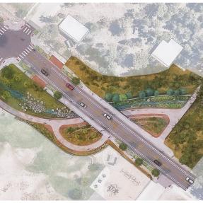
The city and its consultants are currently conducting fieldwork to inform the design of the Gregory Canyon Creek Flood Mitigation Project.
All activities will be exclusively carried out within the City of Boulder’s right-of-way. The work is planned to take place between Thursday, March 28 and Monday, May 13 construction and traffic impacts, please visit https://bouldercolorado.gov/city-boulder-cone-zones-map.

We are still in the information gathering stages of the design work. Please stay tuned for more details about our community meeting planned for the spring.

Project Overview

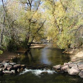
Gregory Canyon Creek originates in City of Boulder Open Space. From the city limits at Flagstaff Road to its confluence with Boulder Creek, Gregory Canyon Creek is approximately 1.8 miles in length and the watershed associated with this creek is approximately 1.9 square miles.

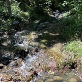
The upper part of the watershed is south of the city limits. Upslope areas are covered with a variety of rock outcroppings, thick residual soils on bedrock, and thicker debris, alluvium, and slope wash deposits that are vegetated with grasses, trees, and shrubs. Deeper soils and wetland vegetation are found on alluvial deposits adjacent to streams. A well-defined channel is visible upstream of Flagstaff Road. The Gregory Canyon trail is located along this section of the creek.

See below for ongoing and past projects, as well as mapping and mitigation information.

Phase I

Flood Mitigation - Arapahoe Ave. to Pennsylvania Ave.

The Vision

Make Gregory Canyon Creek a top-tier waterway, where both people and nature coexist, by reducing flood risks, enhancing stream function, and maximizing opportunities to restore features natural to the stream corridor.

How the creek flows

Gregory Canyon Creek originates in City of Boulder Open Space. The upper part of the watershed, located south of city limits, is covered with a variety of rock outcroppings, and vegetated with grasses, trees, and shrubs. From city limits at Flagstaff Road to its confluence with Boulder Creek, the creek is characterized as a narrow steep channel with dense residential development.

Goals

  • Protect life and property
  • Reduce the extents of the high hazard zone and 100-year floodplain
  • Provide variable natural features representative of the upstream natural watershed
  • Create resiliency for the future
  • Environmental education opportunities

Methods

  • Design to safely convey 10-year storm event without adverse impacts to regulatory 100-year floodplain.
  • Mimic the natural variability of the creek where feasible
  • Develop a unifying aesthetic along the creek corridor
  • Collaborate with the community on the use of the City of Boulder owned properties

Timeline

  • 2013 Flood
  • Dec 2015 Mitigation plan Approved
  • 2017 Highland Bridge Installation
  • Fall 2023 - Spring 2025 Community Outreach, Design Development, Easement Aquisition (Community meeting/Collaborate with the community on the use of the City of Boulder owned properties)
  • Summer 2025 Construction starts

Project Outcomes

Incorporating natural channel restoration into flood mitigation projects can lead to a more vibrant, sustainable and resilient community and environment.

  • Flood Mitigation: Restored natural channels can absorb excess water during heavy rainfall, reducing the risk of flooding in neighborhoods.
  • Property Protection: Stabilized stream banks help prevent erosion, and protect homes and infrastructures located near streams.
  • Improved Water Quality: Natural channel restoration filters out pollutants and sediments, leading to cleaner water.
  • Educational Programs: These projects can serve as educational tools, promoting awareness about watershed health.
  • Community Engagement: Natural channel restoration projects offer opportunities for community members to get involved through volunteer efforts, workshops, and collaborative planning.
  • Climate Resilience: Restored natural channels are better equipped to handle impacts from climate change, providing a more resilient buffer against extreme weather events.
  • Wildlife Habitat: Restoring natural habitats can create homes for diverse wildlife species, enriching the local ecosystem and offering opportunities for wildlife observation.

Community Engagement and Outreach

Q2 2024 - Community Meeting - Gregory Canyon Creek Community Meeting. 5:30 to 6:30 p.m. on May 30 at Boulder Public Library in the Boulder Creek Room, 1001 Arapahoe Ave.

  • Purpose: Updating and informing the community about the progress of the Gregory Canyon Creek Flood Mitigation project.
  • Key Agenda Items will include a summary of the project’s history, updates, next steps, schedule, and FAQs
  • Please feel free to join us in person at the Main Library or virtually on Zoom. The link for our Zoom webinar will be added prior to the meeting. The community meeting will be recorded and posted after the session.

Q4 2023 and Q1 2024 - Office hours - Office hours will resume in June 2024 after our Community Meeting in May. Please feel free to join us in-person at the Main Library or virtually online. The date for office hours will be announced on our calendar, after which you are welcome to book your time with us. We have 6 available 15-minute time slots for Gregory Canyon Creek Office Hours.

Q4 2023 - Design Progress of Phase I - The City of Boulder is excited to kickoff final design of Phase I of the Gregory Canyon Creek Project.

Nature-Based Design

The city strives to help protect people, places, property, and ecosystems in a way that builds resilience and is consistent with community values.

The City of Boulder is partnering with the Mile High Flood District on the design of flood mitigation improvements for Gregory Canyon Creek between Arapahoe Avenue and Pennsylvania Avenue. In January of 2021, Jacobs Engineering completed the preliminary design.

The project includes new channel and roadway culvert structures. In order to build a larger channel and culverts, existing utilities in the area will need to be relocated, including the sanitary sewer and water distribution systems.

As part of the design process, a new flood risk analysis is being completed using updated topography and floodplain modeling techniques. A construction phasing plan is also being developed. Funding for construction is currently proposed in the city's 2023 Capital Improvement Program.

The Gregory Canyon Creek Arapahoe Ave. to Pennsylvania Ave. flood mitigation project has completed the Preliminary Design Drawings. Prior to advancing to Final Design, the project team would like to meet with property owners and residents to answer questions and discuss property acquisition needs.

Next Steps

The project team would like to meet with interested property owners and residents in the area. The project team anticipates reaching out to affected property owners between Fall 2021 and Spring 2025 to arrange individual meetings, conduct community outreach, progress through design development, and initiate easement acquisition. Construction is expected to commence around Summer 2025. Stay tuned for further updates and opportunities to get involved.